From a reality capture data fabric to an operational digital twin

Quick Summary
How DTAP, system-of-systems architecture, common information models, GIS, CMMS/EAM and AI turn visual evidence into operational value
Reality capture is not the finish line. Capturing the building is important. Organizing the data is important. Preserving hidden conditions is important. But the real operational value comes when that operational memory layer shows up in the tools, workflows and decisions people already use every day.
That is where many programs get stuck. The construction team captures the drone imagery, 360-degree walkthroughs, LiDAR scans, SLAM data, inspection photos, point clouds, models, commissioning records and closeout documents. Then the facility team goes back to the CMMS, the reliability team goes back to the EAM, the integrity team goes back to its inspection platform, the GIS team manages maps and layers, engineering uses BIM/CAD, controls teams use BMS/SCADA and documents sit in SharePoint.
The result is predictable: another good dataset becomes another place to look. That leaves another data handoff instead of an operational digital twin.
Reality capture is not the finish line. Capturing the building is important. Organizing the data is important. Preserving hidden conditions is important. But the real operational value comes when that operational memory layer shows up in the tools, workflows and decisions people already use every day.
That is where many programs get stuck. The construction team captures the drone imagery, 360-degree walkthroughs, LiDAR scans, SLAM data, inspection photos, point clouds, models, commissioning records and closeout documents. Then the facility team goes back to the CMMS, the reliability team goes back to the EAM, the integrity team goes back to its inspection platform, the GIS team manages maps and layers, engineering uses BIM/CAD, controls teams use BMS/SCADA and documents sit in SharePoint.
The result is predictable: another good dataset becomes another place to look. That leaves another data handoff instead of an operational digital twin.
The business problem: bring the data to the systems teams already use
Most facility and operations teams already have systems they depend on. Those systems are embedded in business process, compliance, reporting, procurement, maintenance history, planning, safety and daily work. Asking teams to abandon those systems because a new digital twin or reality capture platform is available is usually the wrong adoption strategy.
The better question is: how do we bring the reality capture data fabric to the work instead of forcing the worker to go find the data?
The digital twin becomes operational when it reduces friction. It should connect the right visual evidence, spatial context, asset information, and work process so people can make better decisions without changing everything about how they work.
Think system-of-systems
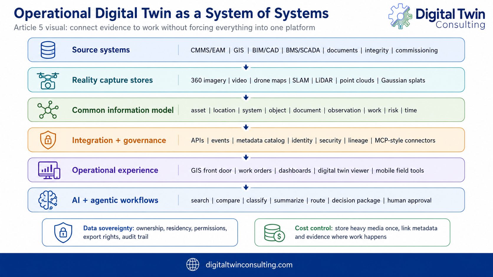
A system-of-systems approach recognizes that CMMS/EAM, GIS, BIM/CAD, BMS/SCADA, document repositories, reality capture platforms, data lakes, digital twins, AI tools and field workflows all have different roles. The objective is to connect authoritative systems through a governed operating model.
- CMMS/EAM remains the system of record for assets, work orders, job plans, maintenance history, labor, materials and costs.
- GIS provides spatial indexing, space context, floor plans, utilities, campus/site relationships and map-based navigation.
- BIM/CAD provides design intent, model geometry, drawings and project delivery context.
- BMS/SCADA provides operating state, telemetry, alarms and control context.
- Reality capture platforms such as DroneDeploy manage heavy visual media, 360 imagery, video, point clouds, scan data, drone maps and change history.
- AI and integration layers connect evidence, relationships, source systems and decision workflows.
Common information models make the data AI-ready
AI-ready data is more than digitized text. Facilities are spatial. Work is spatial. Risk is spatial. Assets are connected physically, electrically, mechanically and operationally.
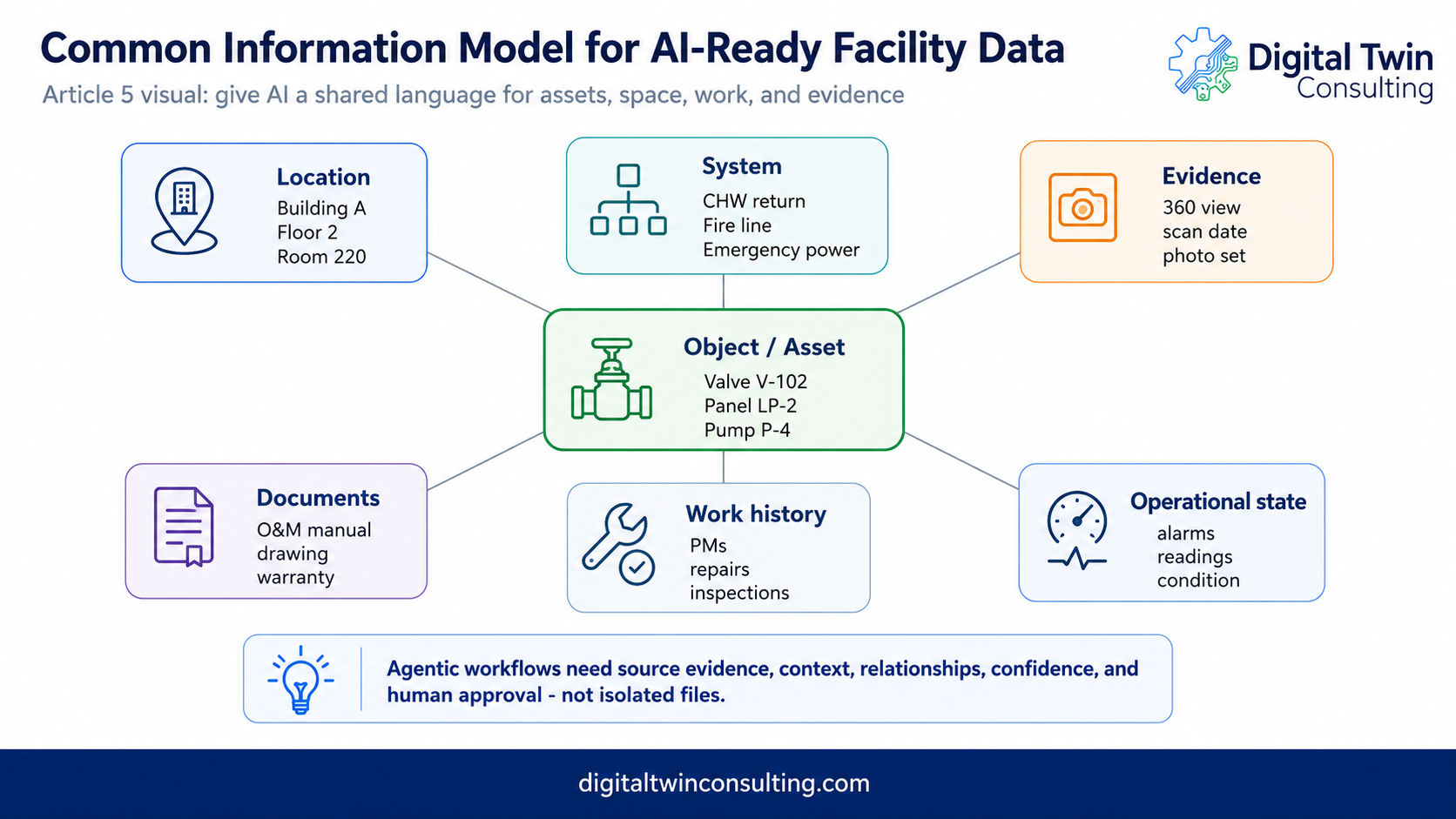
A document may describe a pump. A work order may mention a valve. A 360 image may show the tag. A point cloud may show the clearance. GIS may show the room. BIM may show the design intent. The CMMS may show maintenance history. The BMS may show alarms. The inspection system may show condition.
AI cannot reason reliably across that environment if those pieces are not connected. The common information model provides the connective tissue: shared identifiers, relationships, source-system mappings, and confidence in what each system represents.
In plain English, AI should help find the right asset, place, relationship, condition, event, source and evidence before answering.
Connecting visual evidence to operational relationships
A Common Information Model becomes valuable when it connects visual evidence to the systems and workflows people already use.
If BIM exists, reality capture can be compared against the model to confirm installed conditions and relate captured objects back to modeled assets. If BIM does not exist, the owner can still build useful relationships through asset tagging, object recognition, segmentation, floor plans, drawings, single-line diagrams, P&IDs, CMMS/EAM hierarchies, BAS tags, Haystack tagging, Brick ontology, CMDB relationships or other discovery tools.
The goal is operational context.
A valve in a 360-degree image should be more than a visible object. It should be connected to a space, asset ID, system, isolation impact, operating intent, related drawings, maintenance history, responsible party, service contract and capture event history.
A panel should connect to its room, panel schedule, circuits, downstream assets, inspection evidence, load studies, commissioning records and work history.
A roof drain should connect to roof imagery, slope or drainage evidence, leak history, warranty documents, prior repairs and future inspection events.
This is where a system-of-systems approach matters. CMMS/EAM, GIS, BIM, BMS, document management, reality capture platforms and digital twins each manage different parts of the story. The Common Information Model allows those systems to share enough structure so AI and humans can understand the relationships without forcing everything into one platform.
That is what makes the data AI-ready.
AI cannot reliably reason from disconnected files alone. It needs spatial context, asset identity, system relationships, event history, source evidence and governance. Ontology provides the guardrails that help AI retrieve the right evidence, explain how it got there and support human validation before action is taken.
Storage, sovereignty and cost control matter early
CMMS, EAM, integrity and document platforms are essential, but they were not built to manage every 360 image, video file, point cloud, Gaussian splat, SLAM scan or drone orthomosaic.
Large visual datasets need systems that can handle large media, versioning, permissions, compression, tiling, streaming, spatial indexing, retention and visualization. A work order may need the link, thumbnail, validated finding, asset relationship, date and source confidence. It does not always need to store the full point cloud.
Open architecture matters because owners need flexibility, export rights, data sovereignty, security alignment and manageable long-term cost. The storage architecture should define what lives in the reality capture repository, what is indexed in GIS, what is linked to CMMS/EAM, what is retained for legal or compliance, what is safeguarded by roles and permissions for security reasons, and what is made available for AI retrieval.
GIS can be the first operational interface
For many owners, GIS is the best place to start because everything happens somewhere. A valve has a space. A roof leak has a space. A utility strike has a space. A panel serves a space. A camera sees a space. A fire damper protects a space. A work order happens at a space. GIS can become the spatial front door to visual evidence, asset records, work history, documents and digital twin context.
Object segmentation changes the value equation
A point cloud can be impressive, but it is hard for most operators to use if it remains one massive visual dataset. The value increases when the data is segmented into recognizable objects and systems: valves, panels, pumps, dampers, doors, cameras, ductwork, pipe runs, roof drains, equipment pads, cable trays, fire protection devices, structural elements, rooms and zones. Or if coordinate tags identify assets, spaces, systems and relate important context or other data sets.
Once objects are segmented and entity-resolved against existing records, they can carry information: asset ID, tag number, system name, isolation impact, inspection history, asset condition, work order history, manufacturer data, related drawings, 360 views, scan evidence and source confidence. Classification alone is not enough; extracted assets and spaces must be connected through validated relationships before they safely drive work, automation or state updates.
Agentic workflows: automate the boring hard work
The volume of new data is becoming a problem by itself. Drones, 360 cameras, SLAM scanners, LiDAR, inspection imagery, sensors, BAS data, work orders, commissioning records and documents can create more information than humans can reasonably review manually.
AI and machine learning should help with repetitive, high-volume work: comparing captures over time, flagging visible changes, detecting missing labels, identifying damage or blocked access, extracting asset tags, associating photos with rooms and assets, finding related documents, preparing work-order context, prioritizing inspection findings, routing issues to reviewers and drafting decision packages for human approval. DroneDeploy applies this pattern through its AI agents – Progress AI, Safety AI and Inspection AI.
This is the practical near-term opportunity. Not fully autonomous operations. Not AI making unsafe decisions on its own. The better model is AI doing the boring hard work so humans can make faster, better-supported decisions.
Trust is the operating requirement
In critical facilities, wrong answers have consequences. An AI recommendation that cannot be checked is not useful. A digital twin that looks good but points to stale data is dangerous. A work order generated from bad context can waste time or create safety risk.
- Source evidence: what image, scan, document, drawing, work order, sensor or inspection record was used?
- Date and version: when was the evidence captured, and is it current?
- Spatial confidence: is the finding tied to the right building, floor, room, asset, coordinate or system?
- Asset identity: is the asset ID confirmed, inferred or uncertain?
- Confidence and uncertainty: how confident is the model, and where might it be wrong?
- Human review and audit trail: who validated the finding, who approved the action and what changed?
DTAP connects the data fabric to business value
The Digital Twin Assessment Process, or DTAP, should be the consulting framework that turns reality capture from evidence into an operational program. DTAP is about understanding business needs, operational problems, stakeholders, data structures, risks, integrations, governance, and the path to value before implementation begins.
Reality capture alone is not the digital twin. A BIM model alone is not the digital twin. A GIS map alone is not the digital twin. A point cloud, dashboard, AI assistant or data lake alone is not the digital twin. The digital twin becomes useful when those pieces are connected to the operating decisions the owner needs to make.
DTAP forces the right sequence: start with the business problems, identify stakeholders, assess maturity, prioritize use cases, define the architecture and turn the strategy into Tactical Project Roadmaps that can be funded, sequenced, delivered, measured and scaled.
Strategic Master Planning defines the direction
Strategic Master Planning answers the big questions before an owner spends too much money in the wrong direction. What business outcomes matter most? What decisions should improve? Which assets, systems, sites or workflows create the most value or risk? Which stakeholders need to be aligned? Which systems are authoritative? What data standards are required? What governance model is needed? What cyber-physical security requirements apply? What is the measurable value case?
Tactical Project Roadmaps define the path
A Strategic Master Plan sets the direction. A Tactical Project Roadmap turns that direction into sequenced work. It defines what gets built first, what must be standardized, what data needs cleanup, what integrations are required, who owns each workstream, what vendors or platforms are involved, what security controls apply and what value metrics will prove progress.
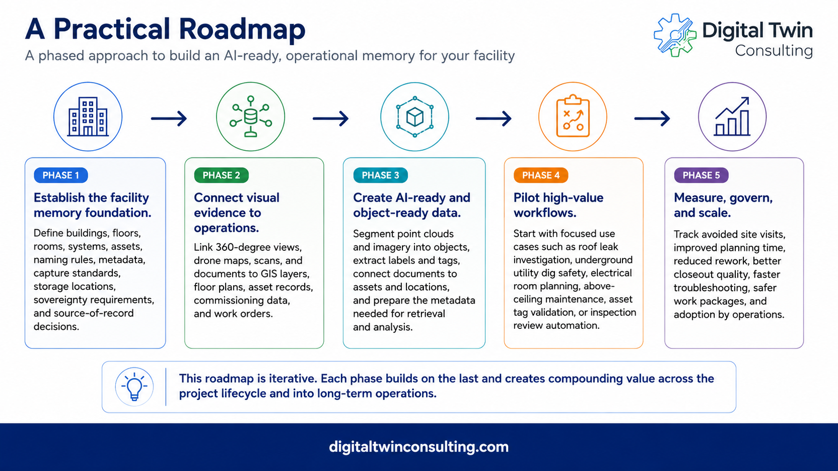
- Establish the operational memory foundation: define buildings, floors, rooms, systems, assets, naming rules, metadata, capture standards, storage spaces, sovereignty requirements, source-of-record decisions and canonical IDs.
- Connect visual evidence to operations: link 360-degree views, drone maps, scans and documents to GIS layers, floor plans, asset records, commissioning data and work orders through asset and space identifiers.
- Create AI-ready and object-ready data: segment point clouds and imagery into objects, extract labels and tags, connect documents to assets and spaces, and prepare metadata for retrieval and analysis.
- Pilot high-value workflows: start with focused use cases such as roof leak investigation, underground utility dig safety, electrical room planning, above-ceiling maintenance, asset tag validation or inspection review automation.
- Measure, govern and scale: track avoided site visits, improved planning time, reduced rework, better closeout quality, faster troubleshooting, safer work packages and adoption by operations.
A practical adoption path
- Use Strategic Master Planning to align stakeholders, business outcomes, governance, AI readiness, storage strategy, security and investment priorities.
- Use Tactical Project Roadmaps to define the first funded use cases, required integrations, data cleanup, capture standards, owner roles, timeline and success measures.
- Define a common information model that connects assets, spaces, systems, documents, inspection events, work orders, parties and visual evidence.
- Use GIS or floor plans as the navigation layer where space matters, or BIM and 3D data when available.
- Store heavy visual data in purpose-built repositories and surface ontology relationships, metadata, thumbnails, validated event findings and governed links inside CMMS/EAM, GIS/BIM and integrity platforms.
- Use AI first for search, comparison, extraction, prioritization and decision-package preparation, while keeping humans in the approval loop for critical operational actions.
What to do next
Use DTAP to define one funded operational digital twin use case. Identify the business outcome, stakeholder group, system-of-systems architecture, common information model requirements, storage strategy, AI risks and tactical roadmap before selecting technology.
Key takeaways
- Reality capture becomes operational when it is surfaced inside the tools people already use.
- Common information models make data AI-ready by connecting assets, spaces, systems, documents, work history, observations, visual evidence and source confidence.
- The operational digital twin should be designed as a system-of-systems that connects authoritative systems rather than replacing them.
- Open architecture protects flexibility, data sovereignty, export rights and long-term cost control.
- Do not force CMMS/EAM, integrity or document platforms to manage huge visual datasets they were not designed for. Use them to connect to the right evidence.
- GIS is often the best starting interface because operational questions usually depend on space, proximity, access and relationships.
- MCP-style connectors and agentic workflows can create value when they are governed, source-traceable and human-approved for critical decisions.
- DTAP connects the reality capture data fabric to business outcomes, stakeholder needs, maturity, governance, architecture, implementation planning and measurable value.
Series closing thought
Reality capture began as a way to document construction progress and support design and modeling. That is still valuable. But the bigger opportunity is the full building lifecycle.
The next step is connecting visual evidence to BIM/GIS, CMMS/EAM, ERP, integrity programs, asset registries, documents, work orders, digital twins, common information models and AI-assisted workflows. When that happens, reality capture is no longer just a visual archive. It becomes a data investment that connects operational systems and supports planning, troubleshooting, safety, work execution, decision-making and better outcomes.
That is the promise of reality capture when it is built for operations: a living operational memory layer that supports the future of operations, instead of a photo dump or closeout folder that dies with the project.
Continue the series
Part of the five-part series Reality Capture as Operational Memory. Read the other articles:
- Part one: Don't let reality capture die at handover
- Part two: Plan reality capture backward from operations
- Part three: Capture it before it disappears
- Part four: From visual evidence to better work management
About the author
Kelly Watt is a digital transformation leader specializing in digital twin technology for aviation, data centers, smart cities, oil and gas and critical infrastructure.

Kelly is the Co-Founder of Digital Twin Consulting. The firm delivers strategic master planning and the proprietary DTAP assessment process to digital transformation projects worldwide.
A frequent collaborator with Georgia Institute of Technology, University of Texas at Dallas and Mohawk College, Kelly focuses on practical digital transformation: strategy before technology, value before complexity and adoption before dashboards.

FAQ
Reality capture is the visual record of what exists on site. A digital twin connects that record to the building's systems, assets, and work history, so it becomes a living model teams use to make operating decisions, not just a set of images.
There is no single best tool. Match the method to the decision: drone maps for site and civil scale, 360-degree walks for fast interior context, and LiDAR or SLAM where measurement accuracy matters. Cost, speed, and required detail decide the mix.
Ready to learn more?
Contact sales to see how DroneDeploy can give your teams the power to document and analyze your sites from the air and ground – all in one AI-powered platform.