October 2026 product release


Quick Summary
DroneDeploy's October 2026 release puts measurable 3D data in the hands of the people walking the job. Ground Pro is now generally available, so a 360 walk produces floor and ceiling maps and a measurable 3D model of each level, and an iPhone or iPad Pro with RTK can scan a trench or an in-slab sleeve to about 1.5 inches. On the aerial side, surveyors tag ground control up to 6x faster, and drone program leads can monitor and troubleshoot every dock from one page.
In this release
- Aerial: GCP Tagging Tool 2.0, Horizontal Map Alignment, Dock Command Center and thermal lens selection
- Ground: Ground Pro GA, Mobile 3D Scans with RTK, Insta360 X6 support, and new map and annotation views in the field
- Platform: the New Explore page, bulk Levels from Procore or ACC, group permissions and Fly tab restriction
DroneDeploy Aerial
GCP Tagging Tool 2.0. Tagging control points is careful, repetitive work, and surveyors usually find a missed checkpoint only after processing has finished. The redesigned tool gives surveyors more map context around each point and advances to the next point automatically, which makes tagging up to 6x faster per control point. Before anything is submitted, it checks for incomplete coverage, missing checkpoints and tags with high residuals.
Horizontal Map Alignment. When one map sits off from the rest of the project, an Enterprise user can align it in XY to another map as the anchor, with no reprocessing or support ticket. Date-to-date comparisons and overlays then line up on every map. It corrects horizontal position only and is not a replacement for a high-accuracy control workflow, and it's available in the New Explore beta.
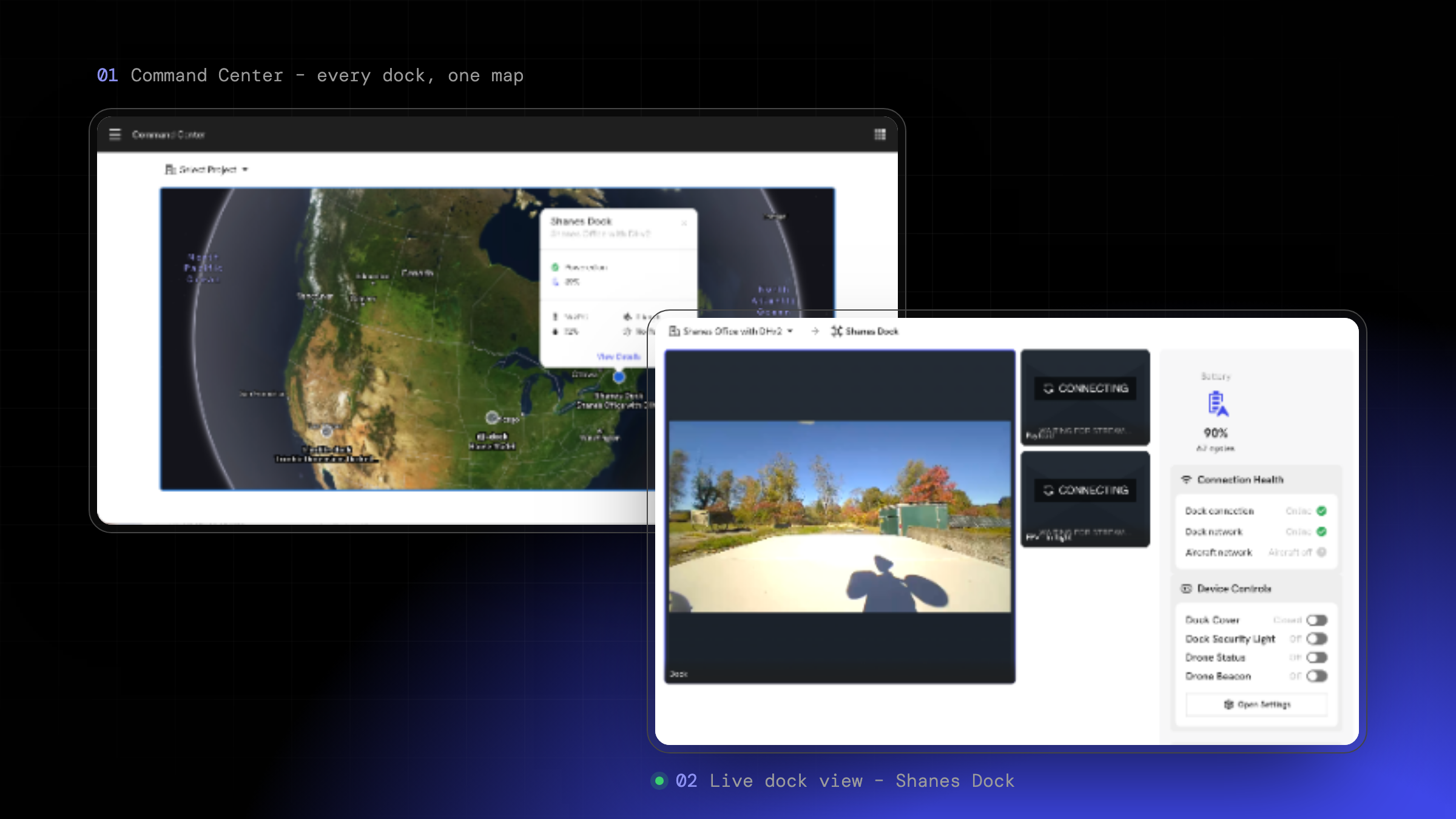
Dock Command Center. Docked drones fly without a pilot on site, so troubleshooting has to happen remotely too. Command Center shows live dock, payload and FPV video for every dock in the organization, alongside battery, upload status, weather and hardware checks. Admins can reboot a dock, restart it or run a network test from that page.
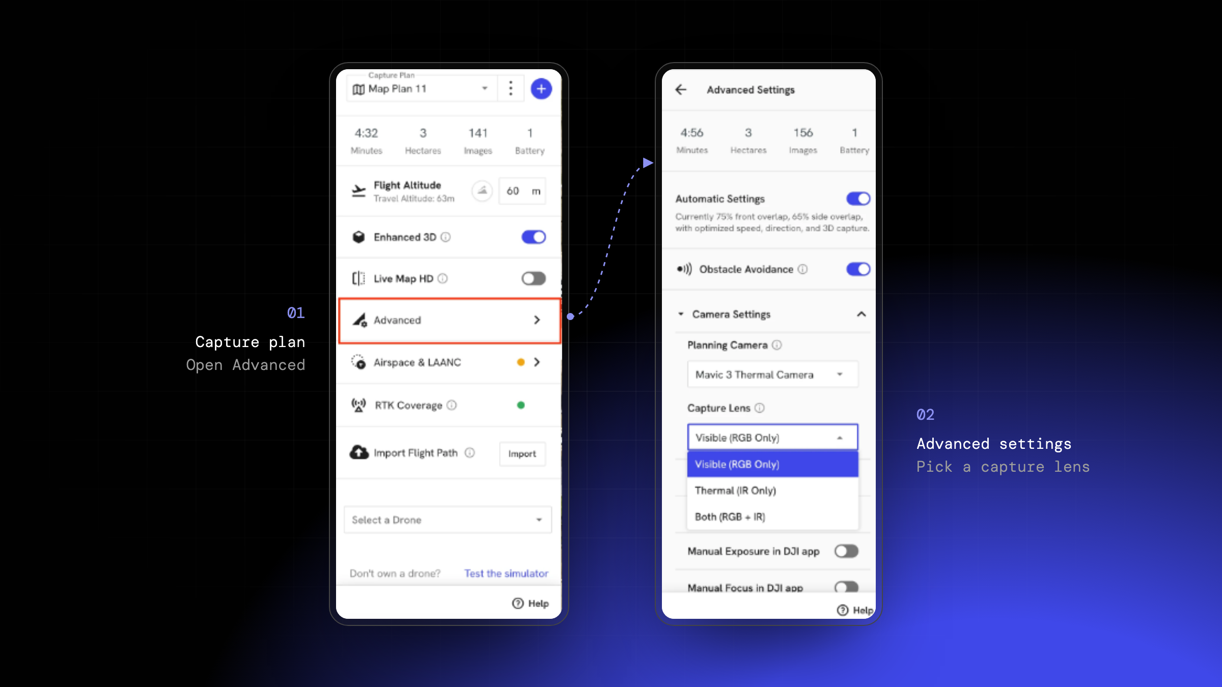
Thermal lens selection. Pilots flying a thermal drone can now plan for the visible lens, the thermal lens or both. Flight path and capture speed adjust to that choice, so an RGB-only mission on a thermal drone finishes sooner and leaves no extra images to clean up.
DroneDeploy Ground
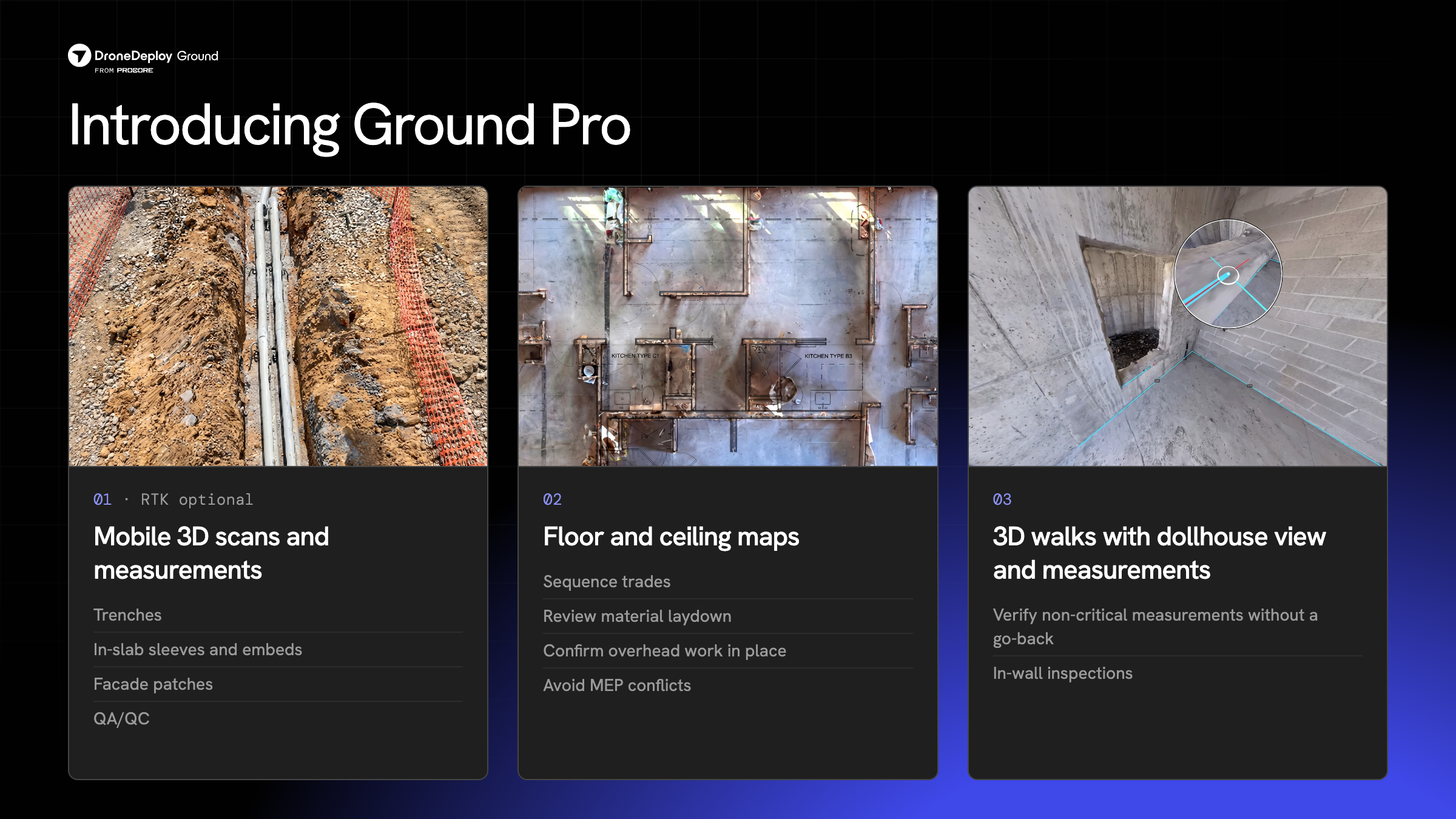
Ground Pro is generally available. Superintendents document in-wall and in-slab work before it disappears, because someone will ask about it weeks later in an RFI or on a punch walk. With Ground Pro, the walk a team already does becomes three views of a level: a floor map, a ceiling map and a measurable 3D dollhouse. A project engineer can check a rough dimension from a desk instead of sending someone back up a ladder to open a ceiling.
Mobile 3D Scans with RTK. Scans cover what a walk or a drone flight won't reach in time. Anyone on the crew with a LiDAR-enabled iPhone or iPad Pro can scan a trench, a sleeve, a facade patch or a stockpile before it gets backfilled or closed in, and adding RTK ties that scan to survey control to about 1.5 inches. Ground Pro teams can also annotate interior floor and ceiling maps the same way they mark up drone maps, then share a snapshot with notes so the right trade knows what to fix (open beta).
In the field. A new map configurator in the Ground app puts dated aerial maps, overlays and annotations in one place, and Ground Pro users can switch to floor and ceiling maps. Field teams tap any annotation to see the same fields they'd see on the web. Insta360 X6 support is in open beta, capturing 8K walks and 120MP panos with 47 GB of built-in storage, and a short guide on the first Record tap covers lighting, coverage and pace for 3D walks.
Reviewing and sharing media. Reviewers can now scan interior media as thumbnails from the sidebar. Any interior photo, pano or walk exports as a single PDF with project context, capture metadata and its location on the floor plan, and an owner or subcontractor can open it without a DroneDeploy login.
Platform updates
New Explore page. Projects with hundreds of maps and thousands of images load in seconds on the New Explore page, which brings interior and exterior into one interface. Annotations, compare, 3D, media, field notes, overlays and exports, including auto exports, all sit in the same view. Every customer can turn on the beta.
Project setup. Setting up a new Ground project meant creating levels one sheet at a time. Teams can now create multiple aligned levels in a few clicks from Procore or ACC Sheets, and drawing revisions sync automatically after that.
Managed access. Enterprise organizations can manage user groups in their own identity provider and sync them to DroneDeploy through SCIM, and each group gets folder and project roles the same way individual users do. Admins can also lock the Fly tab. Only users with Fly permission can then edit flight plans.
For the full list of changes, see the October 2026 release notes. To see how Ground Pro and the new aerial tools fit your projects, book a demo.

FAQ


Ready to learn more?
Contact sales to see how DroneDeploy can give your teams the power to document and analyze your sites from the air and ground – all in one AI-powered platform.