July 2021 Product Release Wrap Up
.svg)

Quick Summary
This July, we’re launching products that improve the inspection process while making it easier than ever for your team to access data.
Manual inspections are time-consuming, expensive, and can be unsafe for your employees. This month we’re introducing a number of tools to alleviate the pain points of manual inspections and better facilitate a remote inspection workflow:
- Issues on Annotations allow you to add issue markers to any annotation, better quantifying the extent of damage or scope of repair.
- The Skydio 3D Scan Workflow provides you with the tools to generate the highest quality digital 3D models on the market so you can inspect every detail of your site or asset.
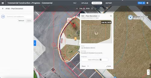
- You can now connect tagged inspection issues to industry-leading construction management solutions Procore and Autodesk BIM 360 and closeout issues with confidence in your system of record.
Given these new site inspection tools, it’s more important than ever for your team, customers, and external parties to have access to data within DroneDeploy. To help you do just that, we’re releasing a new tool to share data across your entire organization.
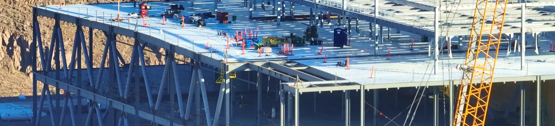
Faster, Smarter Inspections
Issues on Annotations
This July, we’re building on our inspection capabilities to make it easier than ever to annotate, quantify, and share inspection data with your team. Now, you can add an issue to any annotation, whether it be a distance, area, volume, or location annotation. If you are a Procore or Autodesk BIM 360 user, you can then send those tagged issues directly into either platform to automatically create a Procore observation or a BIM 360 issue.
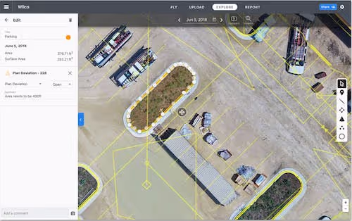
For our customers in construction, you’ll be able to compare maps to design plans and call out differences between reality and the design. Scope of repair inspections can now be quantified in square or linear feet to better estimate the damage and cost of repairs. Issues with site progression, concrete pours, electrical and water line management can be flagged and quantified with a few clicks, then sent to Procore or Autodesk BIM 360 for additional teammates to view and take action.
Our agriculture customers may want to use inspection issues to call out weather damage, such as hail or wind events, for insurance claims. Now, you can quantify the exact acreage of the damaged field, flag it as an issue, then submit that as photographic evidence for your claim.
For our customers who manage properties or facilities, adding issue markers to annotations can quantify areas of damaged pavement or roofs, thus allowing your maintenance team to prioritize repairs and share exact information with vendors.
Available to Business and Enterprise customers.
Skydio 3D Scan Workflow
You can now generate the highest quality 3D models to monitor project progress, conduct infrastructure inspections, and so much more. Powered by the new autonomous capture technology from Skydio 3D Scan and DroneDeploy’s industry-leading Map Engine, your team can autonomously capture data in minutes and generate 3D models that are unrivaled in detail. Because you’re processing with DroneDeploy, all models are available on the cloud, meaning they can be accessed by your entire team, wherever they are, on whichever device they prefer.
Using Skydio 3D Scan for image capture and DroneDeploy for model reconstruction was a seamless process. With less work and stress to take the photos, I ended up with an incredible 3D model I am proud to share.
- Marc Flamm, Enterprise Program Manager, Skydio
Processing your Skydio 3D Scan data in DroneDeploy comes with a range of new benefits. We’ve built a dedicated processing mode optimized for 3D Scans that preserves more detail across the dense collection. The tool will automatically crop your model to the boundary of your 3D Scan set captured by your Skydio drone. We’ve also added new machine learning capabilities to remove sky and horizon in the collected images for a crisper 3D model.
Keep your team safe, decrease inspections times, and reduce spend on swing stages, bucket lifts, and scaffolding by creating detailed digital replicas of any site or asset. Pipe racks, well pads, and storage tanks will have crystal clear definition, enabling your inspection team to prioritize repairs and facilitate remote inspections. Building exteriors or site structures, such as cranes and scaffolding, can be inspected to check for structural integrity and proper installation of building elements.
Available to Business and Enterprise customers.
Automated Issue and Observation Creation in Procore and Autodesk BIM 360
Once we get into the interior phase, we can now retroactively check our walkthroughs and identify any areas we may have missed; then, we can directly send or tag this documentation to workers on-site through the Observation tab. This kind of productivity could only be achieved through centralizing communication between the two platforms.
- Wilson Haworth, Senior Virtual Design and Construction Engineer, Juneau Construction
Before issue tagging within DroneDeploy, teams would perform inspections manually, taking individual photos with their phones and identifying each issue’s location on a floor plan or location tag in their project management tool. This process can take hours to days depending on building size, which sacrifices time and accuracy, often leading to high rework costs for missed issues and project delays.
Tagging issues and auto-syncing to Procore Observations or BIM 360 Docs can now be done in minutes by linking them to high-resolution images with an exact site location. The data becomes more reliable and user-friendly, enabling more thorough inspections, reducing labor costs, and avoiding rework.
DPR Construction performed beta testing on the new integration and explained the value of establishing a single source of data truth between subcontractors and GC’s during this recent webinar.
Syncing Issues can be utilized throughout the entire lifecycle of a project and is most commonly used during the progress tracking phase. On another recent webinar, our beta testing customer McCownGordon demonstrates the use cases of tagging issues for pre-construction, site management, and earthworks to provide time-critical details to all team members on grading activity and utility/infrastructure installation.
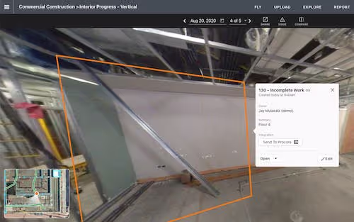
Interior inspections is one of the most common use cases where we see many trades performing drywall, framing, electrical or other work that needs to be validated daily or weekly. Quick issue tagging allows teams to stay on track and resolve any final issues in the project management solutions to finalize payout and confidently move on to the next phase.
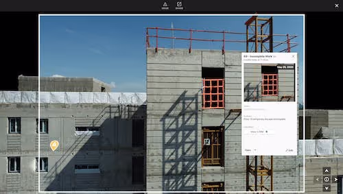
Use cases for exterior buildings are often to support facade inspections, with the issues automatically syncing once tagged after a quick drone flight. This not only reduces the company’s liabilities and risks but saves on high labor costs and time as well as improved safety not manually inspecting from lifts or ladders.
Available to Enterprise customers with the Procore or Autodesk BIM 360 Integrations.
Data for the Entire Organization
Share DroneDeploy easily with your entire organization
Now, it’s easier than ever to give all existing and new employees access to data within DroneDeploy to streamline onboarding and share site maps and models. Admins and Coordinators can share a project or folder with all organization members in one click. When shared, organization members who aren’t already added to the project/folder will get viewer access to it. With this setting turned on, any new employees added to the organization will automatically get access to the shared project or folder.
Available to Enterprise customers.
.png)
FAQ
Related articles


Ready to manage your data from the very start?
Book a quick call to see how DroneDeploy streamlines capture from construction through building ROI.