Renewable energy

Get a live view of every array, turbine and substation

Document your sites with drones, 360 cameras and robots to build a live, shareable record that reduces risk and keeps generation online.
Used on 3 million sites in 180 countries

Cut fitment issues by 35% and time on site by 87%

Design & build

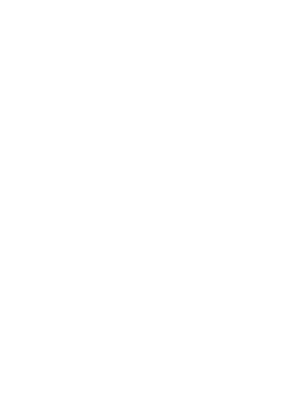
See the site before you break ground.

Use up‑to‑date terrain and layout maps to plan access roads, arrays and cable routes, reducing surprises during construction and cutting rework.
Inspect & maintain

Keep people off panels and towers.

Automate visual and thermal inspections of solar panels, arrays, turbines and substations so crews only roll trucks when and where work is needed.
Monitor & optimize

Protect production over the asset’s life.

Track performance issues, storm damage and degradation with timestamped imagery and reports, so you can prioritize repairs and prove ROI to investors and regulators.

Capture every phase of the asset lifecycle

DroneDeploy Aerial

Site‑wide visibility in every flight
Map solar arrays, turbine pads and substation yards in minutes
Produce high‑accuracy orthos and 3D models for design and as‑builts
Run thermal passes to spot hot strings, failed modules and cabling issues
Measure areas, clearances and volumes to scope work and verify contractors
Track condition over time with dated maps, annotations and exports

DroneDeploy Ground

Autonomous inspections from the ground up
Use robots to capture 360°, thermal and video along rows and in substations
Read labels, barcodes and gauges without walking every aisle or bay
Automate routine walkway, inverter‑room and switchgear checks so robots walk the route, not your crews
Investigate alarms and faults remotely before dispatching technicians
Combine ground walkthroughs with aerial maps for a working visual twin of each site

Need a full feature list and custom quote?

Supported hardware

Build your renewables inspection fleet
(or let us do it for you)
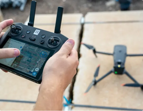
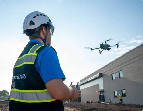
Drones

Our solar drone inspection software captures high‑res RGB and thermal data across solar farms, wind sites and substations. We support leading enterprise‑grade drones, including simplified RTK/PPK workflows and automated GCP handling when survey‑grade accuracy is required.
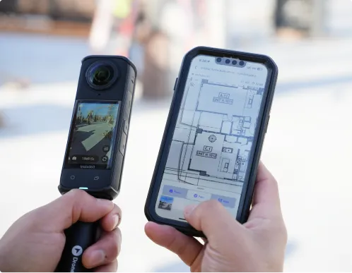
Get the right drone for your sites

360 cameras

Inspect your solar farm from the ground, document control rooms, inverter stations and indoor balance‑of‑plant with 360° walks. Give engineers, OEMs and asset managers virtual access without travel or shutdowns.
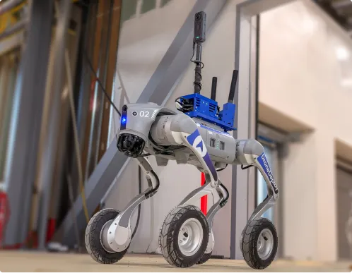
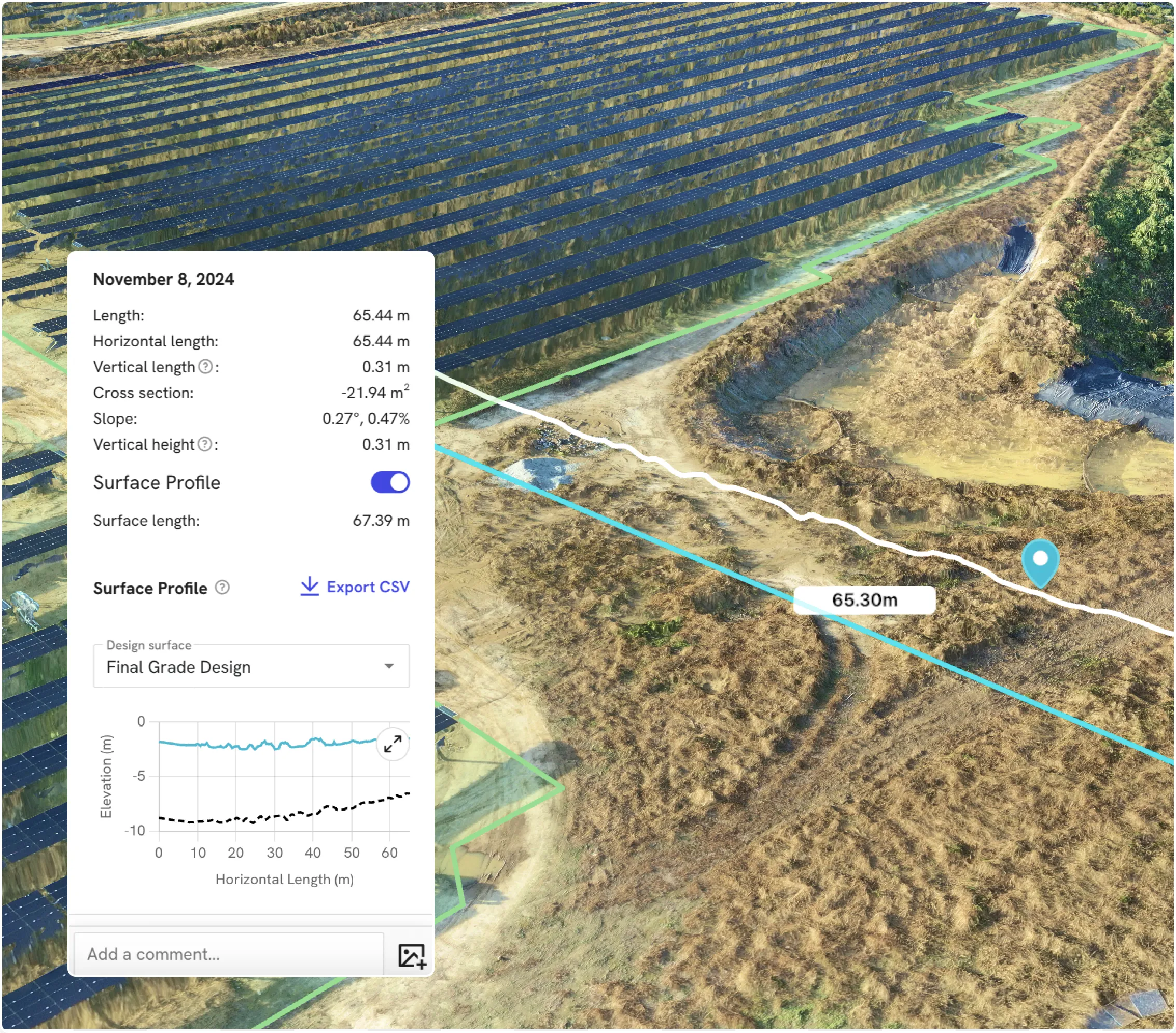
Order a 360 camera kit

Docks and robots

Deploy docked drones and ground robots to run repeatable solar inspection routes along arrays, around turbines and through substations – creating a consistent visual history without sending people into hazardous zones.

Get a robot on your site

Data on demand

Need the data but don't have pilots or hardware yet? Use our services network to capture solar, wind and storage sites at the cadence you need, with processed maps and models delivered straight into your DroneDeploy account.

Get your data delivered to you
Integrations

Don't just collect data – connect it.

See all 80+ integrations

Maximize efficiency and safety across your portfolio

Uber for Drones
Verify design compliance
Cut site visits
Avoid wasted foundations
Detect panel failures
Survey at 1/10th the time
"With Data on Demand, I hit a button from my laptop in Massachusetts and a pilot is on-site within days. It's literally Uber for drones."
Sami Ghantous
Senior Vice President, EPCM
See how
"I overlay KML drawings on drone flights to see if they're tearing up dirt outside the disturbance lines. It saves us from project-halting violations."
Sami Ghantous
Senior Vice President, EPCM
See how
"We verified cable management spacing virtually, saving us weeks of delay waiting for an engineer to fly out and look at the assembly."
Sami Ghantous
Senior Vice President, EPCM
See how
"It uncovered an undocumented well... I can’t imagine the millions of dollars we would have wasted if we had brought foundation crews out."
Patrick Massey
CTO
See how
"It can detect 30 types of internal failures. For every panel not working, that means fewer dollars coming out of the system."
Patrick Massey
CTO
See how
"The amount of time saved is a 30-minute flight versus a week for a survey crew to walk a 25-acre site."
Sami Ghantous
Senior Vice President, EPCM
See how
Frequently asked questions

Is DroneDeploy the right fit
 for your operations?

Do we need in‑house drone pilots to use this?

You don’t. You can start with Data on Demand to order drone flights on‑demand, then introduce in‑house drones and 360 cameras as your program grows.

We already inspect with vendors and manual teams. Do we really need this?

If you’re sending crews into arrays or up towers just to look, you’re taking avoidable risk. DroneDeploy lets you capture the same – or better – detail from a distance, with a reusable visual record for audits and planning.

Is this only for utility‑scale solar and wind farms?

No. It’s used on everything from rooftop and C&I portfolios to large utility‑scale sites. If downtime, truck rolls or safety incidents hurt your returns, you can benefit from reality capture.

Can DroneDeploy meet our security and compliance requirements?

Yes. Enterprise renewable energy customers use DroneDeploy as a central platform for flight operations and data because it offers encrypted data at rest and in transit, role‑based permissions, and enterprise‑grade controls including SOC 2 and ISO 27001 certifications.

Can I trust this data for performance, warranty and insurance conversations?

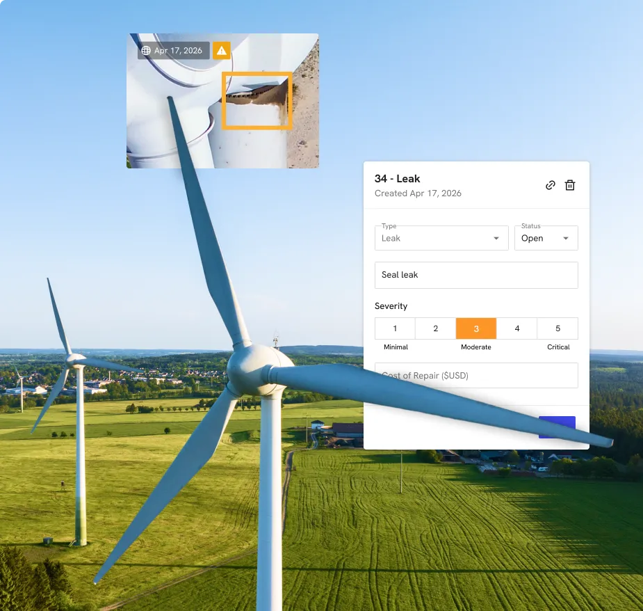
Yes. Measurements and thermal findings are tied to timestamped imagery and maps, so you can show exactly what was installed, when issues appeared, and how they changed over time.

How does this help if I manage assets across multiple regions?

DroneDeploy gives you “eyes on site” in 4K across every project. You can compare sites, approve work and prioritize remediation from your desk instead of flying to each location.

Do we need in‑house pilots and robotics experts to get started?

You can begin with services capture or a small in‑house drone program and expand into high‑accuracy mapping and robotics over time. Our team supports program design, training, and best practices so your survey, planning and OHS teams can ramp quickly.

How does this help if I'm never on the jobsite?

This is built specifically for executive oversight. If you’re managing a portfolio of 10+ projects from a regional office, DroneDeploy gives you "eyes on site" in 4K. You can spot safety risks or schedule slips across every jobsite without ever leaving your desk.

Getting started is simple. Request a demo today.

Book a demo