October 2022 Product Release
.svg)

Quick Summary
Our partners in the drone, robotics and 360-degree camera space are far from slowing their pace in advancing the capabilities of aerial and ground capture. And with our October 2022 product release, we’re proud to announce a number of integrations, features and enhancements that will make sure you stay ahead of the game. With our latest updates, the ability of your reality capture program to capture, process and visualize current site conditions has taken another leap forward.
We have a lot to announce, including beta support in the DroneDeploy Flight app for DJI’s new Mavic 3 Enterprise drone and the RC Pro Enterprise Smart Controller, as well as the first Smart Uploader functionality in the reality capture industry.

Flight & Drone Operations
BETA: Unleash the Power of DJI’s new Mavic 3 Enterprise and RC Pro Enterprise Smart Controller with the DroneDeploy Flight app
We are excited to announce a beta program for the Flight app to deploy autonomous mapping missions on the new DJI Mavic 3 Enterprise drone using the RC Pro Enterprise Smart controller. This means that, for the first time, DroneDeploy is available to install directly on a smart controller – a true turn-key solution that makes for a seamless flight experience.
It is important to note that DroneDeploy is currently only compatible with the Mavic 3 Enterprise and RC Pro Enterprise Smart Controller together.
For more information on how to join the beta and install the DroneDeploy Flight app on your new RC Pro Enterprise Smart Controller please see the beta guide here. For more general FAQs on DroneDeploy’s support for the Mavic 3 Enterprise, please see the FAQ page.
Do you have a Mavic 3 Enterprise and a DroneDeploy account? If so, join the beta now by contacting [email protected] or your Customer Success Manager to gain access.
We look forward to hearing your feedback!

Walkthrough
NEW: Visualize Your As-Designed vs. As-Built Progress with BIM Compare
Now all stakeholders can easily compare actual site conditions from any 360 Walkthrough with the BIM model within DroneDeploy. Our BIM Compare feature brings more 3D insights into how a project is tracking. This new workflow allows anyone on a project to quickly track progress visually, identify issues and clash detections faster, and validate installation according to design.
Before BIM Compare, project managers, superintendents and field teams often relied on VDC teams to communicate progress – lowering the productivity and efficiency of validating work or progress. And architects, engineers and owners would have to physically visit a site to inspect and see a project's progress. This caused delays in schedules, increased costs and more unnecessary rework.
With BIM Compare, your entire team now has access to the BIM model. This empowers GCs to perform more frequent virtual QA/QC inspections and brings the full details of a project to anyone involved, resulting in saved time and better visibility for all stakeholders.
BIM Compare access is included in Project Enterprise plans and is an add-on cost for Enterprise customers with 360 Walkthrough access.
The new BIM data viewer in DroneDeploy has been extremely valuable to ensure quality on our projects. It has also allowed us to show value to our many stakeholders by viewing reality capture data and BIM together to better track quality and progress. We can catch issues before they propagate into something expensive to repair.
- Wilson Haworth, Juneau Construction

NEW: Capture Mobile Photos DURING your 360 Walkthroughs with Photo Walk
Introducing Photo Walk – our mobile photo capture feature, which is now accessible during your 360 Walkthrough capture!
Without any interruption to your 360 Walkthrough, you can collect high-resolution images of any area of interest using your mobile phones, such as MEP installed, gauge readings, equipment conditions/details or punch list items.
Images are then accurately located and tagged to a map, design plan or level alongside your 360 Walkthrough. All of your stakeholders can then review site details from anywhere in the world.
Improving the ground capture process for field teams streamlines documentation and communication between team members. With one solution for all reality capture data, companies will see lowered project costs from preventive maintenance actions and reduced rework.
Photo Walk is included for Project Enterprise and Enterprise customers with 360 Walkthrough.
Currently, I am on a project where I have to walk four unique floors. This new workflow saves me a ton of time on my site walk because I can take mobile photos of things I notice have changed or issues. This new workflow makes it easier to communicate with subs because the walkthrough and photos are tied together – making issue resolution or planning that much easier. All the visual details are now in one place.
- Oscar Martyn, Steele & Freeman
BETA: Upgrade Your Workflows with the DroneDeploy and Avvir Integration
We are happy to announce that we’ve integrated with our partners at Avvir to unlock a smooth pipeline between DroneDeploy reality capture and Avvir’s BIM-focused reality analysis platform for construction. This workflow, which is currently in beta and will be available early next year, will enable teams to track progress using AI to determine the percentage of completion during each phase of work. Read our blog for more details.
Our integration with Avvir is in a closed beta, please reach out to your Customer Success Manager for more information.

Intelligence
UPGRADE: Advanced Esri Integration
Thanks to our enhanced integration, users can now see DroneDeploy maps, photos and issues updated in real time in Esri. Every feature layer is now described by metadata, including some of the most important information you may need to know about your data in DroneDeploy, such as plan type, date of capture and pilot. And for more information and analysis, users can now easily access links back to DroneDeploy projects directly from ArcGIS.
DroneDeploy data is being served instantaneously through Web Map Tile Service (WMTS) and now through Web Feature Service (WFS) with the advanced Esri integration. Finally, there is no longer a need to export and import the data from DroneDeploy to ArcGIS; data access is instantaneous on both the organizational level and the project or plan level.
The integration to Esri is an add-on cost for Teams and above account types. The new features are included in the integration cost. Contact your Account Manager or Customer Success Manager for more information. Or submit your request here.
BETA: Cut Your Upload Time in Half with the Smart Uploader
With the new Smart Uploader, which is still in beta, you can simply drag and drop all the media you captured on your project into the Upload tab and the Smart Uploader will sort your data into the correct categories automatically.
This functionality virtually eliminates the need for you to manually sort aerial imagery, giving you more time to focus on the things that matter. In this latest release, we have added the capability to process GCPs in the Smart Uploader to ensure your workflow stays as streamlined as possible.
Every paid user with DroneDeploy will have access to the new Smart Uploader. For now, users will continue to be able to use our legacy uploader if desired.
Smart Uploader is available to all paid users in DroneDeploy. GCPs are available at the individual level at $49/map or included in the Advanced, Teams and Enterprise account levels.
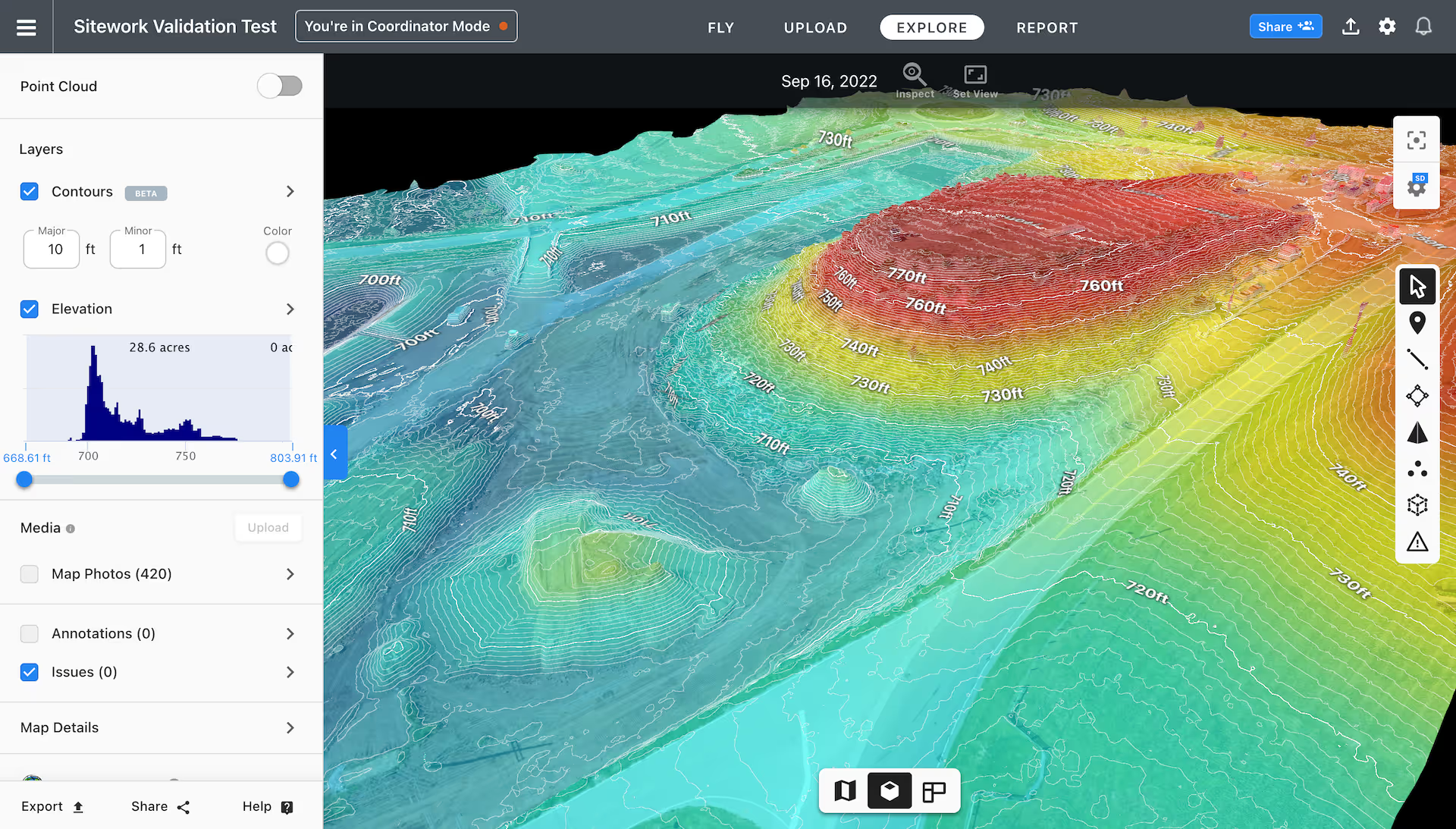
NEW: View Contours and Elevation in 3D
You can now view contours and elevation in 3D, allowing you to quickly see changes in grade across your entire site. Your teams will become more efficient and make better-informed decisions by visualizing the existing conditions overlaid with elevation data.
The combination of contours with our elevation tool in 3D allows you to have a full earthwork experience without having to use complex online software or need to export 2D contours to desktop software. With these tools, you can say “goodbye” to your engineering drawings.
Contours and Elevation in 3D are available to Individual customers and above.

Ground Robotics
NEW: Deploy Robots at Scale with Autonomous Oil and Gas Facility Inspection
With the DroneDeploy Ground Robotics solution, you can send robots on regular and pre-scheduled autonomous missions to inspect oil and gas sites, assets, and equipment. Collect rich data on your assets, detect maintenance issues early, reduce or prevent downtime and reduce the need for workers to enter hazardous environments.
In this release, we have added new sensors and availability to remotely capture walkthroughs using your 360 cameras and high-resolution imagery from the SpotCAM. You can view close-ups of all of your gauges, thermal imagery of assets and 360 photos of your facility, all geolocated in your DroneDeploy project and collected autonomously.
You can remotely control robots from anywhere to investigate ad-hoc issues such as abnormal IoT and SCADA sensor readings, or to gather data for planning maintenance and upgrades. You can get “eyes” on the ground without endangering workers – allowing your team to virtually be in more than one place at one time.
And because this data is now integrated into the DroneDeploy platform, your team can see how assets have changed over time and find potential issues early. You can also annotate any issues and share auto-generated reports with key stakeholders.
BETA: Receive Alerts Automatically From Analog Gauge Readings
We are excited to launch the integration of machine learning models to read analog gauges. You will receive an alert if any reading is outside of set thresholds. This is a closed beta available to current Ground Robotics customers. Let your Customer Success Manager know if you are interested in being part of the beta.
NEW: Build Better With Autonomous Construction Reality Capture
DroneDeploy Ground Robotics is the ideal reality capture solution for large construction projects – such as data center builds – where it’s important to regularly capture visual data of building interiors. In this release, we have added support for the Leica BLK ARC, which is used for mobile mapping.
With DroneDeploy Ground Robotics, robots can be sent on pre-scheduled autonomous reality capture missions to capture 360 walkthroughs and LiDAR data on construction sites. Track construction progress, share data with stakeholders, validate subcontractor work and generate point cloud data for BIM/VDC teams to compare with design models. All without painstaking manual inspections or slow terrestrial scanning.
Schedule reality capture missions to happen overnight or first thing in the morning so the data is clear of people moving around and is also ready for the site team to plan their day once they get in.
The Ground Robotics solution is an additional cost for customers. You can contact the team here to request a demo or talk to your Customer Success Manager to learn more.
DroneDeploy just works – it does exactly what we needed and expected the solution to do. We save four to five man hours with each 15-minute automated mission with Spot.
- Chris McKee, Turner Construction
Missed our Previous Updates?
Find out how we’ve improved DroneDeploy in recent months:
.png)
FAQ
Related articles
Ready to manage your data from the very start?
Book a quick call to see how DroneDeploy streamlines capture from construction through building ROI.