April 2022 Product Release
.svg)

Quick Summary
In this release, we continue to expand on our vision of bringing all site reality data into one solution, giving our users a 360-degree perspective of any job site, asset, or structure.
Today, we're making it that much easier to capture mobile photos and establish more visual context in your workflow. With the addition of new integrations, we continue to support our mission of making a simpler, more automated way of collecting and processing data.
In this April Release, we are excited to announce:
- Mobile Photo Capture. As you walk and document your site with our Walkthrough App, you'll now be able to capture and auto-upload mobile photos with your 360 videos, garnering a close-up perspective of any assets.
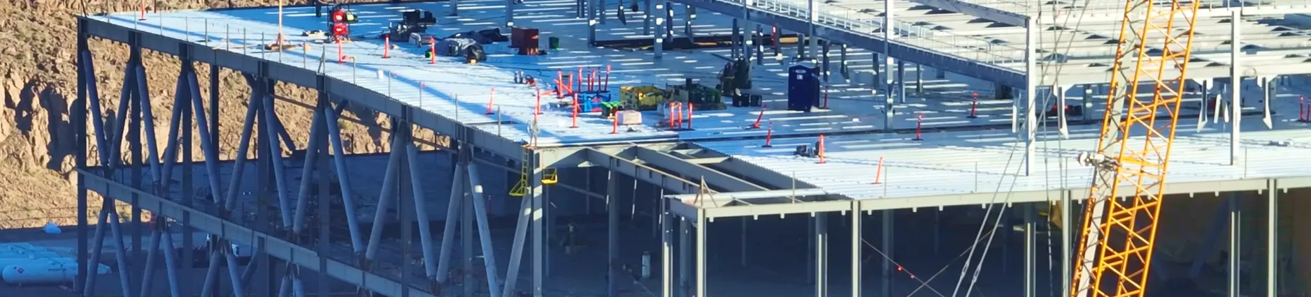
- The DroneDeploy x Skydio Cloud Integration. This gives you the ability to transfer your 3D Scans from Skydio seamlessly into your DroneDeploy project while processing any 3D Scan into a comprehensive model.
- DJI Mavic Air 2 support for Stand Count flights. With increased reliability and new drone support, you can capture insights in minutes.
- And finally, added accessibility with our new native Data on Demand app and the ability to signup or sign in with a Microsoft Social Login.
Mobile Photo Capture with the Walkthrough App
The new Mobile Photos feature in the DroneDeploy Walkthrough App is an easy way for field crews to quickly capture high-resolution images of issues or flagged areas of interest during planning, inspections, site walks, and asset inspections. Mobile images are accurately located and tagged to a DroneDeploy map or floor plan on a level. Each photo is then automatically uploaded to the project for all stakeholders to review from anywhere.

During pre-construction, phase completions, or close-out walks, field teams can now take mobile images as they walk their sites, with this imagery supporting the creation of photo reports documenting completed tasks and current site conditions. This new view enables teams to quickly filter and search mobile photos taken from anywhere on their sites. And with drone maps and 360 Walkthroughs, this workflow adds a new perspective to completed punch lists and further detail to as-built documentation, no matter the build phase.
The same goes for any energy facility or site, especially when conducting visual inspections for condition documentation. Now, users can easily capture mobile images that will add visual details of an asset's condition or operating status to regular reports. This new data empowers teams to quickly filter and search mobile photos of tanks, utility structures, pipelines, breaker panels, and more, regardless of physical location. By adding mobile photos for enhanced 360 Walkthrough inspections, teams can engage in ongoing preventative maintenance.
Requires a 360 Walkthrough subscription to access.
New Integration to Skydio Cloud
DroneDeploy users can now upload imagery captured on any Skydio drone to DroneDeploy using Skydio Sync. Users will now be able to identify and select which scan data they’d like to import into DroneDeploy to create high-resolution 2D orthomosaic maps and 3D models, which enable efficient remote inspections and progress tracking. This integration simplifies the data transfer from the Skydio Cloud to DroneDeploy, streamlining operations when flying with Skydio and analyzing data with DroneDeploy.

We're excited to bring this industry-first integration to the market. And the best part? This new workflow saves critical hours of uploading and processing time. If you're a drone pilot, all you'll need to do is fly and create scans with any Skydio drone. After accessing your project within DroneDeploy, you'll then be able to pull in any drone imagery from any Skydio drone within a 10km radius. DroneDeploy will then process those images into high-resolution maps and models.
Read more about the new integration to the Skydio Cloud.
Requires a DroneDeploy Teams or Enterprise subscription to access, as well as subscriptions to Skydio Cloud and 3D Scan.
Stand Count and DJI Mavic Air 2 Support
DroneDeploy Stand Count is a comprehensive flight, capture, and analysis workflow designed to determine crop emergence for early-stage fields. As a result, you can automate your entire Stand Count workflow and reduce the traditional method by 90%. As a reminder, our solution can map fields in minutes to conduct stand counts, identify variability, and make in-field recommendations, all offline at the field's edge.

In this release, we have improved reliability and performance by 25% in preparation for the North American planting season. We've also added the DJI Mavic Air 2 to our list of supported drones for Stand Counts. See our full list of supported drones, as well as this helpful checklist to make sure you're both successful and prepared for the upcoming season.
Stand Count functionality is available to all paid accounts (Ag Lite and up).
New Flight Request Workflow
DroneDeploy now offers professional drone flight services to our teams and enterprise customers through the new Data on Demand workflow. Depending on your needs, we can augment your existing in-house program, or you can completely outsource your drone flight requirements to us. With the new Data on Demand workflow, all capture requests and data delivery now happen within the DroneDeploy platform — no external app is needed.
Each flight request can be tailored to your workflow and needs. Our ecosystem of drone pilots flying Data on Demand flights are trained and vetted by DroneDeploy. We guarantee that drone data is delivered on time and up-to-spec so your team can focus on making decisions.

Access Data on Demand from any map plan on the Fly tab of your project. You no longer need to use an external app to request flight services, as the workflow is now native to DroneDeploy.
Each flight request includes a summary of the total flight time and the number of flight templates at the bottom of the pop-up form to confirm the details of your request, as seen below.
To enable Data on Demand for your organization, please contact your sales executive or reach out to us here.
Microsoft Social Login
Along with Google and Apple social login, now Microsoft users have a simple way to sign in to DroneDeploy. You do not need to create a new account but use an existing account to authenticate with DroneDeploy.
.png)
FAQ


Ready to manage your data from the very start?
Book a quick call to see how DroneDeploy streamlines capture from construction through building ROI.