DroneDeploy Recommended Hardware
Current customer? Reach out to your account team to purchase hardware directly from us.
Core to our roots, DroneDeploy is hardware agnostic.
Our processing engine was built to work with data collected from any camera source.
We offer support for automated flight modes for leading drone models, and are mission planning and execution compatible with a wide range of ground robots, docked drones and 360 cameras.
Interested?
Get in Touch


.webp)
.svg)
.webp)
.webp)


.svg)
.webp)
.svg)
.webp)
Recommended Drones
DroneDeploy supports various drone models for flight and processing.
Compare drones by clicking the "compare" button on the top left of each product.


Supported by DroneDeploy for: Flight and processing
Mavic 3 Enterprise RTK
$$
Origin: China
Description & Advantages
Description:
DroneDeploy’s Flight app for the Mavic 3 Enterprise series allows Advanced, Teams and Enterprise customers to enjoy reliable RTK coverage by automatically connecting to local high-accuracy RTK corrections networks at no additional cost.
Advantages:
45-minute flight time
Compact and portable - 915g
Radiometric processing supported with the Mavic 3 Thermal
RTK and PPK capable, supported with DroneDeploy’s RTK Flight App
120HA coverage at <1.5in/px GSD


Supported by DroneDeploy for: Flight and processing
Matrice 4 Enterprise
$$
Origin: China
Description & Advantages
Description:
The DJI Matrice 4 Enterprise series captures large sites faster for enhanced efficiency. An additional 3x zoom lens enables detailed asset inspections, and automatic connection to local RTK correction networks delivers high-accuracy positioning at no extra cost.
Advantages:
49-minute flight time
21 m/s (47 mph) flight speed
3x + 7x zoom lenses
Improved obstacle avoidance
Radiometric processing supported with the Matrice 4 Thermal
RTK and PPK capable, supported with DroneDeploy’s Flight App


Supported by DroneDeploy for: Flight and processing
Anzu Raptor RTK
$$
Origin: USA
Description & Advantages
Description:
DroneDeploy’s Flight app for the Anzu Raptor allows Advanced, Teams and Enterprise customers to enjoy reliable RTK coverage by automatically connecting to local high-accuracy RTK corrections networks at no additional cost.
Advantages:
45-minute flight time
Compact and portable - 915g
Radiometric processing supported with the Anzu Raptor T
RTK and PPK capable, supported with DroneDeploy’s Flight App
120HA coverage at <1.5in/px GSD
No geofencing


Supported by DroneDeploy for: Processing Only
WingtraOne
$$$
Origin: Switzerland
Description & Advantages
Description:
WingtraOne is an easy-to-use fixed-wing drone that delivers consistent, high-quality survey data.
Advantages:
59-minute flight time
Approved Blue UAS cleared list
Compatible with high-resolution Sony cameras
PPK enabled (DroneDeploy PPK support coming soon)

Supported by DroneDeploy for: Flight and processing
DJI Air 2S
$
Origin: China
Description & Advantages
Description:
Capture a variety of media types including panos, maps, and more, fully autonomously. Suitable for surveying smaller areas.
Advantages:
30-minute flight time
Portable and lightweight drone - 595g
Supported with DroneDeploy’s Flight App
20MP camera, 1-inch CMOS Sensor
ADS-B for safe flight

Supported by DroneDeploy for: Processing only
DJI Matrice 350 RTK
$$$
Origin: China
Description & Advantages
Description:
This next-generation drone features a new video transmission system and control experience, a more efficient battery system, and more comprehensive safety features, as well as robust payload and expansion capabilities.
Advantages:
55-minute flight time
DJI RC Plus smart controller
Compatible with Zenmuse P1 payload, DJI’s most robust photogrammetry camera
RTK/PPK enabled

Supported by DroneDeploy for: Processing only + data transfer via Skydio Sync
Skydio X10
$$$
Origin: USA
Description & Advantages
Description:
The Skydio X10 boasts high-resolution visual and radiometric cameras in modular sensor packages.
Advantages:
35-minute flight time
Approved Blue UAS cleared list
Skydio Cloud sync with DroneDeploy
VT300-L version has 1” wide, 50MP camera, optimized for mapping
DroneDeploy PPK supported

Supported by DroneDeploy for: Processing only
Freefly Astro
$$$
Origin: US
Description & Advantages
Description:
Freefly’s latest commercial drone platform with RTK, 61 megapixel Sony camera, LTE cloud connectivity, mission computer and more.
Advantages:
37-minute flight time
Approved Blue UAS cleared list
Compatible with Sony’s latest 61MP mapping camera, the ILX-LR1
RTK/PPK enabled (DroneDeploy PPK support coming soon)
Thermal and multispectral payload options
Comparison

Drone
Drone
For an exhaustive list of our latest flight-supported
drone models, visit our Help Center.
Explore DroneDeploy Aerial
Give your teams the power to fly drones, capture and organize photos, generate maps and inspection reports, and share easily – all in one AI-powered platform.
Start Mapping
Recommended Cameras
DroneDeploy supports a wide range of 360 cameras and either .INSV or .MP4 video files. Recommended cameras include:


Supported by DroneDeploy for: Capture & Processing
Insta360 X5
$$
Description & Advantages
Description:
The Insta360 X5 is a rugged, compact, high-performance 360° camera for precision reality capture. With 8K video and excellent low light performance, it is ideal for documenting interior progress, capturing tight spaces, and producing high quality walkthroughs.
Advantages:
8K 360° video captures ultra-detailed visuals for crystal-clear site documentation.
Advanced stabilization for crisp images in any environment
Triple AI chip for superior low light performance
Replaceable lens design for less downtime
20 minute quick charge and 37% more battery life keep you working


Supported by DroneDeploy for: Capture & Processing
Insta360 X4
$$
Description & Advantages
Description:
The Insta360 X4 is a rugged, high-performance 360° camera for precision reality capture. With 5.7K/60fps video, it is ideal for documenting interior progress, capturing tight spaces, and producing high quality walkthroughs.
Advantages:
High resolution, high speed video frame rate for the best walkthroughs
72MP 360 degree panos provides crystal clear images
Lightweight, compact design keeps you going
High capacity battery for those long site walks


Supported by DroneDeploy for: Capture & Processing
Insta360 ONE RS 1-inch
$$
Description & Advantages
Description:
DroneDeploy users can expect superior 360 panoramas and videos in the Walkthrough app thanks to the One RS 1-inch's:
Advantages:
Dual 1-inch CMOS sensors
6K 360 capture
21MP 360 photos
Excellent performance in low-light conditions

Supported by DroneDeploy for: Capture & Processing
Ricoh Theta X
$
Description & Advantages
Description:
The Ricoh Theta X is designed for fast, high-resolution reality capture. With touchscreen controls and 11K photo capability, it's ideal for documenting interiors, walkthroughs, and tight spaces for capturing as-built conditions and progress with minimal setup.
Advantages:
Captures 11K 360° photos for detailed interior documentation.
Intuitive controls for fast, in-field operation
Lightweight design makes it easy to carry and deploy across active jobsites.
Removable battery & SD card enables extended capture sessions without downtime.
Seamless integration with DroneDeploy Ground for automated uploads and organized site records.

Comparison
Drone
Drone
For an exhaustive list of our latest supported camera models, visit our Help Center.
ExploreDroneDeploy Ground
Give your teams the power to walk sites with 360 cameras, capture and organize photos, overlay maps onto floor plans, generate inspection reports and share easily – all in one AI-powered platform.
Start Documenting
Recommended Ground Robots
DroneDeploy offers mission planning, execution, data transfer support for the following ground robots – and almost any ROS or Mavlink-based models.

Boston Dynamics Spot
Description & Advantages
Description:
Made by US-based Boston Dynamics, Spot is an agile mobile quadruped robot that navigates terrain with unprecedented mobility, allowing you to automate routine inspection tasks and capture data safely, accurately and frequently.
Advantages:
Designed for inspection and manipulation tasks
Uses 360° perception to map terrain and avoid obstacles
Carries payload of up to 14kg
Weather and dust resistant (IP54)
Balances dynamically in uncertain surroundings
Can cruise over loose gravel, grass and stairs

OnSight
Description & Advantages
Description:
OnSight is an autonomous and teleoperated unmanned ground vehicle with a radiometric thermal imaging camera and an optical zoom camera that uses AI visual learning to detect, report, and observe issues and anomalies on utility solar farms.
Advantages:
AI-driven, computer vision robotic platform for solar sites
Designed for large remote sites, providing essential data and analysis
Radiometric thermal imaging camera and an optical zoom camera
Can inspect up to 360 miles per month
60% lower inspection costs compared to sending a team out
Comparison
Drone
Drone
Explore DroneDeploy Ground Robotics
Give your teams the power to perform scheduled missions with ground robots, and then upload data automatically – all in one AI-powered platform.
Start Teleoperating
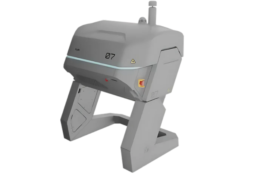
Recommended Docked Drones
DroneDeploy offers flight planning, execution, data upload and data processing support for docked drones or “drone-in-a-box”.

Supported for: Flight Automation & Processing
DJI Dock 3
$$
Description & Advantages
Description:
DJI Dock 3 delivers faster, more reliable autonomous missions in extreme environments.
Advantages:
Utilize DroneDeploy’s superior flight planning capability
Leave drones on site to perform remote missions and recharge
Data is automatically uploaded to DroneDeploy after capture
Improved insulation and IP56-rated weather protection
Supports M4D and M4TD drones, which are equivalent to M4E and M4T
49-minute flight time, 21 m/s (47 mph) flight speed
Recommended industries / use cases
Inspections
Thermal applications
Facility management


Supported for: Flight Automation & Processing
DJI Dock 2
$
Description & Advantages
Description:
A lighter, more portable, and faster Dock. The DJI Dock 2 houses an M3D or M3TD drone, enabling it to land, recharge, take off and execute missions. It’s built to operate 24/7 and withstand harsh weather conditions.
Advantages:
Utilize DroneDeploy’s superior flight planning capability
Leave drones on site to perform remote missions and recharge
Supports M3D and M3TD drones, which are equivalent to M3E and M3T
M3D is a great mapping drone with 20MP wide camera with mechanical shutter
Data is automatically uploaded to DroneDeploy after capture
Significant weight reduction of 68% and a size reduction of 75% compared to DJI Dock 1
Dual RTK antennas on the Dock ensure that a deployed aircraft can get an even more accurate positioning
Wind resistance of 12 m/s and an IP55 rating
Recommended industries / use cases
Aerial mapping
High-accuracy workflows
Project / site management with changes over time
Data transfer via Skydio Extend, data visualization from processing on Skydio servers
Skydio Dock
$$$
Description & Advantages
Description:
The Skydio Dock is a lightweight yet heavy-duty drone-in-a-box option, designed and manufactured in the US. It offers advanced vision-based navigation and obstacle avoidance, making it perfect for complex autonomous flights such as tower inspections.
Advantages:
Leave drones on site to perform remote missions and recharge
Cutting-edge autonomous navigation and obstacle avoidance
Easily upload and process flight data via Skydio Cloud Sync
Small and light - footprint of 4 square feet, weighs just 62 pounds
Can be operated in tight and complex spaces
IP56 weather protection
Recommended industries / use cases
Complex inspections
Thermal workflows
Conditions requiring complex autonomous flights
.png)
Comparison
Drone
Drone
Explore Dock Automation
Give your teams the power to perform scheduled missions with docked drones and ground robots, and then upload data automatically – all in one AI-powered platform.
Start Teleoperating

Read our Drone & Robot Hardware Guide
Download Now
Still not sure about the best hardware for your business?
2
Items for comparison

| Comparison | ||
|---|---|---|
.webp) Mavic 3 Enterprise RTK |  Mavic 3 Enterprise RTK | |
| Point 1 | 45-minute flight time | 30-minute flight time |
| Point 2 | RTK and PPK capable, supported with DroneDeploy’s RTK Flight App | Supported with DroneDeploy’s Flight App |
| Point 3 | 120HA coverage at <1.5in/px GSD | 20MP camera, 1-inch CMOS Sensor ADS-B for safe flight |
| Point 4 | Radiometric processing supported with the Mavic 3 Thermal | - |
| Point 5 | Compact and portable - 915g | Portable and lightweight drone - 595g |
