How OceanaGold Uses Drone Data to Manage Mine Restoration
.svg)

Quick Summary
OceanaGold’s Reefton team in New Zealand uses DroneDeploy to manage mine restoration more efficiently, saving over $30,000 AUD annually by eliminating the need for external survey contractors. Previously limited to one costly survey per year, they now fly and process site data covering 550 hectares in a single day, using over 4,000 photos. This enables frequent progress tracking, precise tree planting plans, and streamlined stakeholder reporting. DroneDeploy’s user-friendly software and data sharing have transformed their operations, even helping fulfill regulatory obligations with the Department of Conservation.
$33,000
minimum cost savings (AUD) by surveying in-house
4,000
photos taken for their 550-hectare site
1
day needed to fly & process the entire Reefton site
At OceanaGold, restoration is an essential part of the mining life cycle. With operations in both the North and South Islands of New Zealand as well as the Philippines and South Carolina, sustainability is at the forefront of their operations and maintained by an overarching responsible mining framework. For Jeff Nyenhuis, Reefton Restoration Project Coordinator, this is a full-time job.
While overseeing the Reefton mine's total restoration process in New Zealand, Jeff is also responsible for managing all contractors on-site, hitting progress targets, and completing site surveys. Understandably, this is a lot for one person - which is why in 2019, Jeff and his team began using DroneDeploy to survey the mine and compare against design plans, track progress, and measure stockpiles. The effects of drone technology resulted in huge time, cost, and labor savings for the organization, propelling them to expand the technology’s reach with data sharing to other teams. With a yearly bond review coming up, we checked in with the multinational gold producer on how they’re using DroneDeploy within their program today.
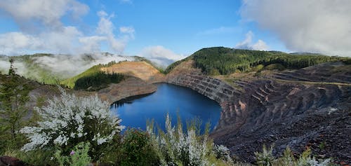
OceanaGold's Reefton Mine in New Zealand.
Reducing Contractor Cost for Mine Restoration
The OceanaGold Reefton team already had a drone on-site when they realized they could begin using the hardware for site inspections. “We were already paying contractors $10,000–$20,000 (AUD) to do this work anyway,” Jeff explains, “so why not do it ourselves?” Macraes, a fully operational OceanaGold mine, was already using DroneDeploy and recommended the Reefton team start with simple flight paths. Always looking for ways to reduce time spent and complete the same work more cost-effectively, the team began testing DroneDeploy for a host of different tasks. Through this trial-and-error process, Jeff ascertained that the software could track work, measure critical functions, and design site plans. After sharing this information, Jeff and the Environmental team determined that DroneDeploy would also be used to calculate areas for tree planting. The ease-of-use and autonomy that came with DroneDeploy’s software were the key differentiators for purchase.
We can get data exactly when we want it.

Jeff Nyenhuis, Reefton Restoration Project Coordinator, OceanaGold
Previous to utilizing drone technology, the Reefton team relied on a host of contractors and subcontractors to manually survey, process, and analyze data. Although they already had drones, without a powerful software to stitch maps end-to-end, the data was mostly unusable without a contractor’s manual analysis. This was a multiple weeks–long job, averaging up to $20,000 AUD; because of the considerable access barriers, a full site survey could only be accomplished once a year. Today, this is an entirely different process.
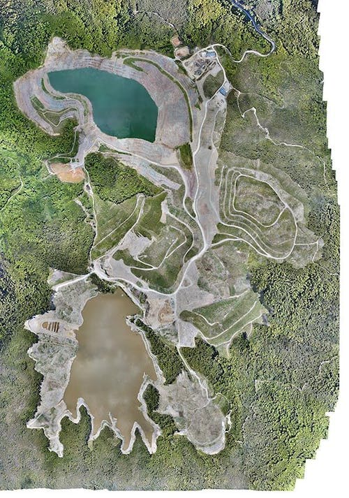
An orthomosaic map of the Reefton site.
Capturing, Analyzing, and Sharing Data Across Teams
Prior to the COVID-19 pandemic, Jeff captured data on-site once a week to determine exact movements and project progress. Currently, this frequency is about once a month, but DroneDeploy’s data sharing capabilities have reduced the pandemic blow by keeping all stakeholders informed in just a few clicks.
In-app, Jeff tracks contractor progress and shares this information with other teams. One of Jeff’s personal challenges was reading multiple complex datasets at once, so he enjoys DroneDeploy’s reporting features for their easily digestible format. Since he can fly, process, and receive results in just one day, he can easily pass this data on to the appropriate bodies. Because there’s no delay in getting data back, the Reefton site synchronizes their data with Macraes for quicker and more complete processing. Not only is Jeff assured that the information he’s receiving is accurate, but it’s also saving their company a significant amount of money.
By surveying in-house, we’re saving a minimum of $30,000 (AUD) a year.
Jeff Nyenhuis, Reefton Restoration Project Coordinator, OceanaGold
Tracking and Updating Renewal Access Agreements
Because the Department of Conservation (DoC) owns the land where the mine rests, Jeff and his team have to operate under special requirements. He frequently flies the entire site for bond review and films these flights twice a year for OceanaGold’s Board of Directors. Once the rehabilitation program is completed, the site will be handed back to the DoC. Until then, OceanaGold will work closely with the DoC to update the bonds and closure plans to ensure the best long term outcome for the site.
In the future, Jeff and his team are looking forward to updating their hardware in order to receive accurate data even faster. Their current site sits on 550 hectares, comprises over 4,000 photos, and can be flown and processed all in one day. “We never would’ve thought we would be able to accomplish this five years ago,” Jeff states, “and we can get much more time out of the day.”
If you’re interested in using drone applications for your mining challenges, watch our webinar on getting started with drones in mining, or download our eBook on untapped resources in mining and quarrying.
.png)
FAQ


.jpg)
Ready to manage your data from the very start?
Book a quick call to see how DroneDeploy streamlines capture from construction through building ROI.